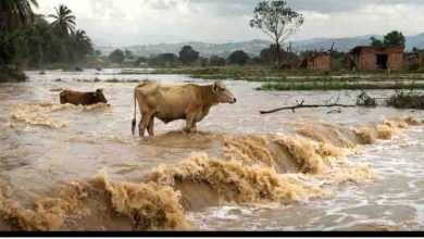
New report shows alarming changes in the entire global water cycle
In 2022, a third La Niña year brought much rain to Australia and Southeast Asia and dry conditions to the other side of the Pacific. These patterns were expected, but behind these variations there are troubling signs the entire global water cycle is changing.
Our research team watches the global water cycle closely. We analyze observations from more than 40 satellites that continuously monitor the atmosphere and Earth’s surface. We merge those with data from thousands of weather and water monitoring stations on the ground.
For the first time, we’ve drawn on those many terabytes of data to paint a full picture of the water cycle over a year for the entire globe, as well as for individual countries. The findings are contained in a report released today.
The key conclusion? Earth’s water cycle is clearly changing. Globally, the air is getting hotter and drier, which means droughts and risky fire conditions are developing faster and more frequently.
The year in a nutshell
In 2022, a third consecutive La Niña influenced weather around the world. Three La Niña years in a row is unusual but not unprecedented.
A La Niña is an oceanic event in which sea surface temperatures are cooler than normal in the central and eastern tropical Pacific and warmer than normal in the western Pacific. The phenomenon strengthens easterly trade winds that bring rain to southeast Asia and Australia.
In 2022, La Niña combined with warm waters in the northern Indian Ocean to bring widespread flooding in a band stretching from Iran to New Zealand, and almost everywhere in between.
The most devastating floods occurred in Pakistan, where about 8 million people were driven out of their homes by massive flooding along the Indus River. Australia also experienced several severe flood events throughout the year—mostly in the east, but also in Western Australia’s Kimberly region at the very end of the year and into 2023.
As is typical for La Niña, the rain was much less plentiful on the other side of the Pacific Ocean. A multi-year drought in the western United States and central South America saw lakes fall to historic lows.
Another year of drought also decimated crops and led to a rapidly worsening humanitarian situation in the Horn of Africa.
A change in the rains
Although our data do not suggest a change in average global rainfall, there are troubling trends in several regions.
The monsoon regions from India to Northern Australia are getting wetter. Parts of the Americas and Africa are getting drier, including the western United States, which experienced its 23rd year of drought in 2022.
Monthly rainfall total records appear intact. But rainfall over shorter periods is becoming increasingly intense in many regions.
As our report highlights, intense rainfall events struck communities across the globe in 2022—from Brazil, Nigeria and South Africa to Afghanistan, India and Pakistan.
The downpours caused flash floods and landslides, killing thousands and leaving many thousands more without a home. Growing population pressures are pushing ever more people into floodplains and onto unstable slopes, making heavy rain and flood events even more damaging than in the past.
A hotter, drier world
Average global air temperatures are rising. While La Niña years are historically relatively cool, that effect is largely lost in the upward march of global temperatures.
Heatwaves are increasing in severity and duration and this was noticeable in 2022. Apart from being natural disasters in their own right, heatwaves and unseasonally high temperatures also affect the water cycle.
In 2022, intense heatwaves in Europe and China led to so-called “flash droughts.” These occur when warm, dry air causes the rapid evaporation of water from soils and inland water systems.
In 2022, many rivers in Europe ran dry, exposing artifacts hidden for centuries.
Air is not only getting warmer but also drier, nearly everywhere. That means people, crops and ecosystems need more water to stay healthy, further increasing pressure on water resources.
Dry air also means forests dry out faster, increasing the severity of bushfires. In 2022, the western U.S. experienced major fires in January, in the middle of Northern Hemisphere winter.
Warmer temperatures also melt snow and ice faster. The Pakistan floods were made worse by a preceding intense heatwave that increased glacier melt in the Himalayas. This raised river flows even before the rains hit.
Climate change is not the only way humanity is changing the water cycle. There has been a steady increase in the volume of lakes worldwide. This is mostly due to individuals and governments constructing and enlarging dams to secure their access water, which changes river flows downstream.
Welcome to the future
La Niña’s influence appears to be waning, and a switch to an El Niño halfway through this year is possible.
Hopefully, that will mean fewer flood disasters in Asia and Oceania and more rain for drought-affected regions in the Americas and East Africa.
Australia, however, may see a return to heatwaves and bushfires. In the longer term, 2023 may mark the start of another multi-year drought.
The seesawing between El Niño and La Niña is a natural phenomenon. But it remains to be seen whether the triple La Niña was a statistical fluke or a sign of disruption from climate change.
If La Niña or El Niño stays around longer in future, we’re likely to experience deeper droughts and worse floods than seen to date.
Humanity’s success in reducing greenhouse gas emissions will determine the planet’s future several decades from now. Until then, global temperatures will continue to increase. New records will continue to be broken: for heatwaves, cloudbursts, flash droughts, bushfires and ice melt.
There is no way to avoid that. What we can do is heed the warning signs and prepare for a challenging future.
The 2022 report and the underlying data are publicly available via www.globalwater.online.


